More Projects
59 in total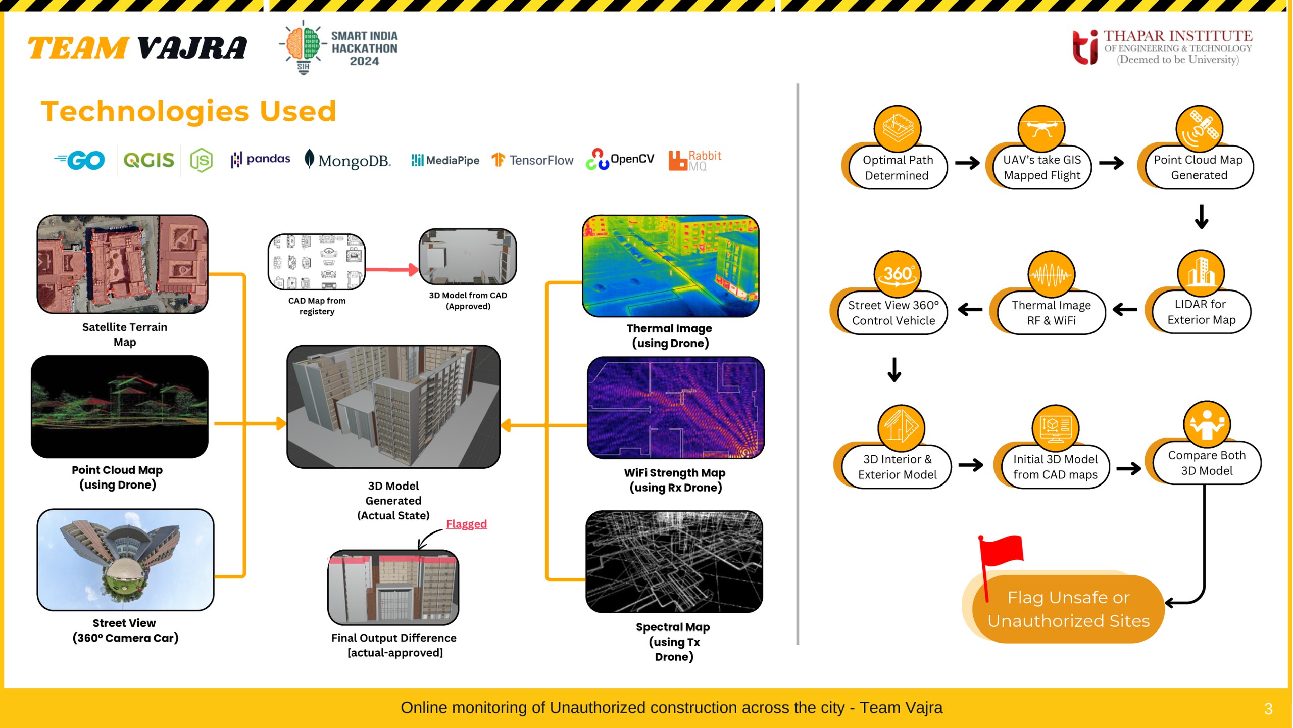
PlotPatrol - Unauthorized Construction Monitoring
Team Vajra - Smart India Hackathon 2024 · 2024
Winning Smart India Hackathon 2024 entry for problem statement 1618: detecting construction that departs from its approved plan, without sending an inspector. The submitted system pairs a transmitter and receiver drone that map a building interior from WiFi and RF signal strength without entering it, LiDAR point clouds, thermal passes for cracks and deformation, and a 360-degree street-view car, then builds a 3D model and diffs it against the CAD registry plan to flag the actual-minus-approved delta. The prototype in the repo covers the satellite and comparison half: a Sentinel-2 median composite, a ResNet50 and SSIM difference mapper, drone survey path planning and an RF signal-strength heat map.
Smart India Hackathon 2024 — Winner
 Python
 Google Earth Engine
 TensorFlow
 Keras
Keras OpenCV
 scikit-image
 Flask
Flask Leaflet
Project Details
Team Vajra - Smart India Hackathon 2024
2024
Smart India Hackathon 2024 — Winner
Hackathon · AI
Municipal bodies approve a building plan, then have no practical way to check whether what got built matches it. An inspector has to physically visit, get inside, and measure - which is why enforcement runs weeks behind construction and mostly does not happen at all. PlotPatrol answers the question from imagery instead. It won Smart India Hackathon 2024 under problem statement 1618, built by Team Vajra.
The submitted system
The idea that carried the pitch was measuring a building's interior without entering it. A transmitter drone and a receiver drone fly a paired sweep, and the way WiFi and RF signal strength attenuates between them across the structure gives you interior walls and floor layout from the outside. Around that:
- LiDAR point clouds for the exterior envelope.
- Thermal passes for cracks and deformation, which also flags structural work that was never declared.
- A 360-degree street-view camera car for the ground-level facade.
- Satellite for the footprint and the change baseline.
Those feed one 3D model, which is diffed against the CAD plan held in the municipal registry. The output is the delta: actual minus approved. The economics were the other half of the argument - inspection time falling from weeks to hours, inspection cost down 40 to 60 percent, against 10,354 acres encroached in 2024 and over Rs 7,640 crore needed to recover it.
What we actually built in the window
The prototype covers the satellite and comparison half of that pipeline, plus the drone control and RF groundwork. The core comparison is approved plan versus actual structure, assembled from four sources:
- Satellite. A Google Earth Engine script exports a low-cloud Sentinel-2 median
composite over a bounding box, giving a clean baseline free of the transient cloud and
haze that make single-date imagery unusable.
sat-map.pypullsCOPERNICUS/S2across 2019-01-01 to 2024-01-01, keeps only scenes withCLOUDY_PIXEL_PERCENTAGEunder 10, takes the median, clips to the region and exports to Drive at 10 m per pixel withmaxPixelsat 1e13. - Registry. The approved CAD plan, converted to a 3D model.
- Drone. Point-cloud, thermal and spectral passes over the actual structure.
- Street view. 360 degree camera imagery for the ground-level facade.
A Flask service then compares before and after images. ResNet50 with include_top=False
and average pooling turns each 224x224 image into a feature vector, and cosine similarity
between the two vectors is the gate. The tolerance is 1e-6, so anything short of an
identical pair falls through to localisation: cv2.absdiff thresholded at 30 paints
changed pixels magenta and scores the delta as a percentage of the frame, while SSIM's
difference image is Otsu-thresholded and contoured, with every contour above 40 px boxed.
The output is a difference map showing where the built structure departs from the approved
one, against a real Delhi before/after pair.
What is in the box
- Sentinel-2 composite exporter driving Earth Engine's batch export straight to Drive.
- Plan upload service on Flask, accepting
jpg,dwgandsvgso a sanctioned plan and a captured image land in the same folder. - Difference map generator writing paired SSIM overlays for the two inputs.
- Raster plan vectoriser that fetches a sanctioned plan from the MCD citizen download
endpoint and runs Gaussian blur, Canny at 50/150, contour tracing and
svgwriteto produce a polygon outline of the approved footprint. - Pincode choropleth over the 92 polygons in a 1.5 MB
delhi-pincode.kml, drawn with Leaflet and leaflet-omnivore on OSM tiles, with a world-sized mask polygon dimming everything outside the city. - Inspection scheduler where clicking a zone opens a form for the approved plan, the drone swarm date, and a monitoring window of one to five years, matching the satellite composite's own five-year span.
- Drone survey path planner generating a boustrophedon sweep: 200 scanlines between the polygon's north and south bounds, edge intersections solved by linear slope, only the two-intersection lines kept, joined by alternating connectors.
- Quadcopter control over raw UDP to port 8800, sending 8-byte hex frames every 50 ms through an idle, altitude-hold, arm and emergency-stop sequence.
- Live drone page pairing an RTSP camera feed with the generated flight path for the zone being surveyed.
- Serial RSSI heat map reading a 9600-baud link, parsing
Signal strength (RSSI):lines, normalising -90 to -30 dBm onto a 10x10 grid and decaying it 0.95 per frame so stale cells fade. This is the first step of the buddy-drone idea: get signal strength onto a spatial grid, then worry about inferring walls from it. - Site context lookup running a Places nearby search for schools, hospitals and industry inside an operator-drawn polygon, alongside a 1920x1080 satellite pull.
- KML splitter emitting one boundary file per pincode for per-zone processing.
Honest scope
Worth being clear about the gap between the two sections above. The buddy-drone interior mapping, the LiDAR point clouds, the thermal crack detection and the street-view car are the submitted architecture - the system as pitched and judged. They are not in the prototype. What is in the prototype is the satellite-to-difference-map chain, the survey path planner, the quadcopter link and the RSSI grid.
The rest of the honest scope: the image comparator is a vendored third-party component rather than something trained on building footprints. The pipeline exports one composite rather than running a continuous time series. The heat map places each reading on the grid at random instead of pairing it with a GPS fix, so it demonstrates the display and not the survey. Roughly 2,900 lines of hand-written code across 27 files. What it does demonstrate is the full chain, registry plan through to flagged difference, working end to end on real Delhi imagery.
Project Details
Team Vajra - Smart India Hackathon 2024
2024
Smart India Hackathon 2024 — Winner
Hackathon · AI